Bank Street, Irvine, Ayrshire, Scotland.
POSTCODE———————————–KA12 0AA
LOCATED————————————-The town of Irvine lies roughly twelve miles north of Ayr. The entrance to the stadium was on Bank Street, and was located about half a mile north of Irvine town centre
ORIGINAL SITE——————————Grazing land.
DATE CONSTRUCTED———————1933
DATE VENUE OPENED——————–August 1933.
Meaning other sports may have taken place prior to the arrival of Greyhound Racing.
FIRST MEETING—————————–August 21st 1933.
Greyhound Racing only.
LICENSED OR INDEPENDENT———–Independent
All venues covered would have to be licensed with the government, licensed suggested in this section would refer to tracks operating under NGRC Rules.
INSIDE OR OUTSIDE HARE TYPE——-Inside Sumner during its latter years.
Please note that the Electric Hare suggested is only a guidance and would have been in operation for a certain amount of time at this venue. Although it is not necessarily guaranteed that it was operational all the time, as other types of lure may have been used and updated as time progressed.
DISTANCES————————————325, 525 and 725 yards.
Please note that most racing venues distances had become varied throughout the years, the ones given above were at once point set and offers only a guidence to the track size.
CIRCUMFERENCE—————————400 yards.
Please note that alterations at most racing venues throughout its existence would see that the circumference of the track would vary, the one shown above offers only a guidance to the track size.
BIG RACE NAMES—————————Marymass Handicap.
STADIUM SHARED WITH——————Nothing found.
LAST MEETING——————————-April 18th 1996.
Greyhound Racing only.
STADIUM CLOSURE DATE—————-1996
Meaning other sports may have taken place after Greyhound Racing had ceased.
STADIUM DEMOLITION——————–Late 1990’s
BUILT ON SITE——————————–Nothing known of as yet.
In some cases, structure’s that originally covered the venue after the stadium had been demolished, may have been themselves demolished too, so the one described is more likely to be the one which now presently covers the site.
EVIDENCE LEFT TODAY——————–The tarmaced access road is still there, with trees and shrubbery still outlining the stadiums location and clearly visible on Google Earth.
FURTHER COMMENTS———————None


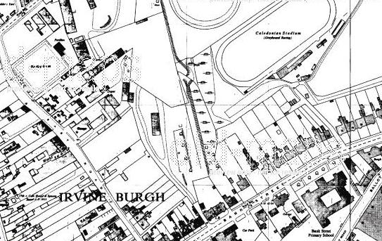


Irvine is a town located on the North Ayrshire coastline roughly twelve miles north of Ayr. Irvine became another town that could boast it supported two greyhound tracks at one time, both opening within nine months of each other during the early 1930’s.
The first one was known as Townhead, a track situated less than half a mile south west of the town centre, with the other one described in this chapter as the Caledonian Stadium, a venue situated roughly half a mile east of the town. The track had been constructed on a section of grassland situated between Quarry Road and Bank Street, and had two covered stands, both on its south eastern side, which overlooked the start and finish straight, which in itself had a slight gradient. The track had long straights and tight bends and had a circumference of 400 yards, which created distances of 125, 325, 525 and 725 yards.
Opening up as a flapping track, its first meeting came on the 21st of August 1933, with races consisting of six greyhounds chasing a trackless type of hare. The track promoters later installed an outside McKee Scott type hare, before switching to an inside Sumner type during its latter years.
Its final meeting came a Thursday evening of the 18th of April 1996, with the demolition of the stadium following soon after, yet the site lay totally abandoned for many years following, leaving nature to invade the site with weeds and shrubs. It is still not yet clear whether the site has been built on or not, but satellite views still offer its location, with the shape of the track and its tarmacked access road clearly evident behind the houses on Bank Street.
A programme, photograph or even memorabilia for this track is required for this page, if you can help please contact me.
Recent Comments